1 Project Statement
Through performative and transformative design, the landscape architect helps to rebuild the bound between the uprooted people and the natural and cultural root, and recover the sense of belong and identity
This project demonstrated a performative and transformative solution to meet the multiple challenges facing the developing world today: fast urbanization with abandoning of traditional farming wisdom and agricultural landscapes, floods and other water issues threating the new urban residents, and the lack of recreational space and expensive maintenance cost
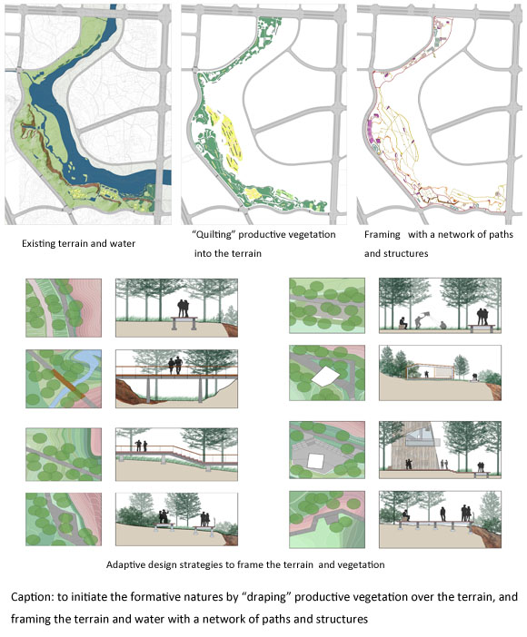
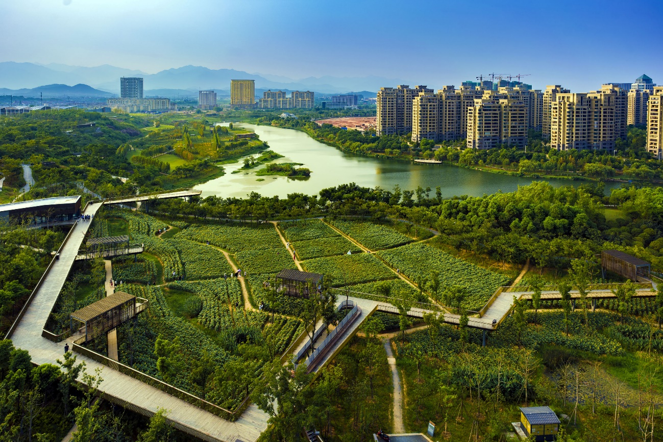
The landscape architect took a deserted site at the edge of the fast growing city Quzhou as a great opportunity to explore innovative concepts to realize a performative and transformative landscape that is not only a recreational green space, but also serves as an ecological infrastructure that provides holistic ecosystems services. The landscape is created by incorporating the traditional agricultural strategy of crop rotation and low maintenance meadows that enrich the soil with nutrients needed by other crops. An elevated network of boardwalks, bridges, platforms, pavilions and a viewing tower form a circulation network that provides visitors with a rich set of interactions with the mosaic landscape of the “first” and “second” natures, and creates a visual frame for these natures. This network, while detached from the “canvas” of the landscape mosaic below it, effectively transforms the performative and productive “messy” natures into a pleasing array of interactive experiences.
2 Challenges and Objectives
The project is located at the west bank of the river called Shiliang Creek, at the West New District of Quzhou City, in Zhejiang Province, with a population of 2.5 million. The city is known to the world due to its strategic location at the east coast area in China, boasting a history of over 1,800 years. During the world war two, the small airport at Quzhou was planned by the US air force as the landing place in the Doolittle Raid (the Tokyo Raid), on 18 April 1942.
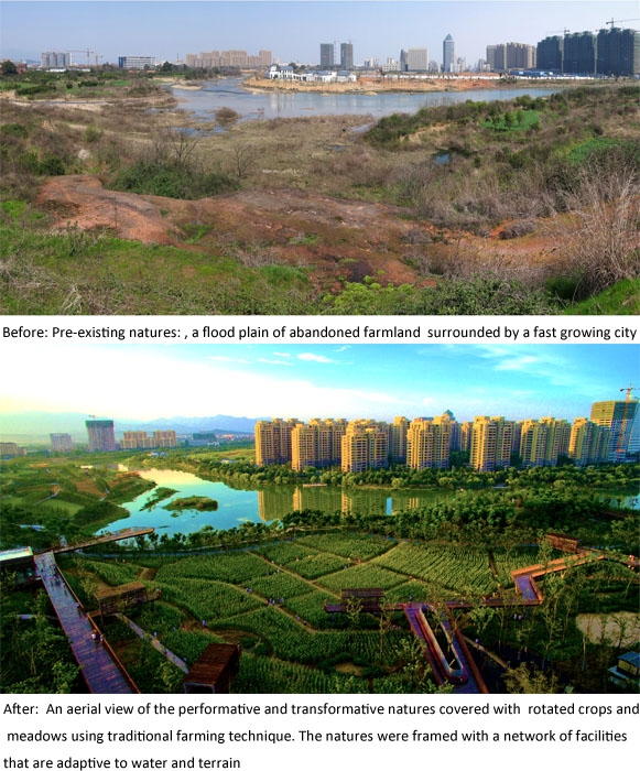
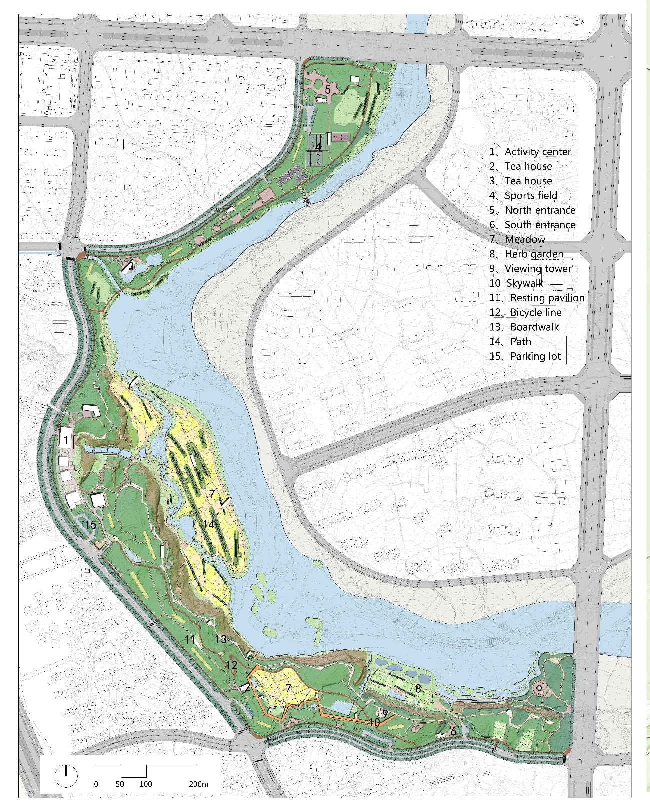
With a total area of 32 hectares, the site was surrounded by all intensive development and was bounded by the creek at the west and an urban through traffic road at the east. It is a remnant landscape patch made of rolling hills covered with a mosaic of red sandstone exposure, vegetated patches of bushes and grass, and small patches of farm land, and a riparian flood plain down to the river basin, and a linear tree grove along the river edge. Scattered in this landscape mosaic are some small village trail sections paved with river stones with an old resting pavilion, an irrigation ditch leading to a pump house at the cliff that fetch water from the river. From the urban road up on the hill to the riparian flood plain is an elevation difference of 20 meters that created a sandstone cliff at the water front. The site would have been easily leveled to flat ground as were done in the surrounding landscape under development including park making, a conventional approach to the development of large new urban district in China (and in many other places in the world). Simply because this rugged landscape mosaic is not considered valuable nor aesthetically pleasant, the cultural landscape elements are nothing significant, and by leveling the ground to flat will make the whole mechanical and engineering processes much simpler and easier to lay down the infrastructure of all kind of pipes and roads and even storm water drainage.
The client’s request is simple that the park be a multifunctional green space that provides recreational opportunities for the people in the city, The landscape architect take this opportunity to explore some of the cutting edge ideas of what a large urban park could be so that it will not only be a recreational green, but an ecological infrastructure that will provide holistic ecosystems services, and be able to address some of the big issues such as climate change, food and energy security, water resilience, and a new landscape aesthetic of productivity and low maintenance. Ideas like making friends with flood, agricultural urbanism and productive landscape, minimum intervention, performative landscape, etc. are integrated into a landscape transformation strategy: Draping over the terrain and water.
3 Design Strategy:Draping over the terrain and water
The transformative strategy of Draping over the terrain and water is executed at the following four aspects:
(1) Preservation of the landscape assets
The mosaic landscape pattern and its natural processes is kept unchanged at its most; The rock exposure and cliff, the bush and grass over, the natural drainage system and the fluctuation of river water, the agricultural field patches, and the trees lining the river bank. The cultural landscape elements including the village trails with the old pavilion, the irrigation ditch with pump house, are all take as cultural heritages of the site, and be preserved and fixed to keep its original character. These natural and cultural landscape, with their authentic functions and meanings make up the canvas with rich pattern and texture and meanings, which the landscape architect will add layers of his creation.
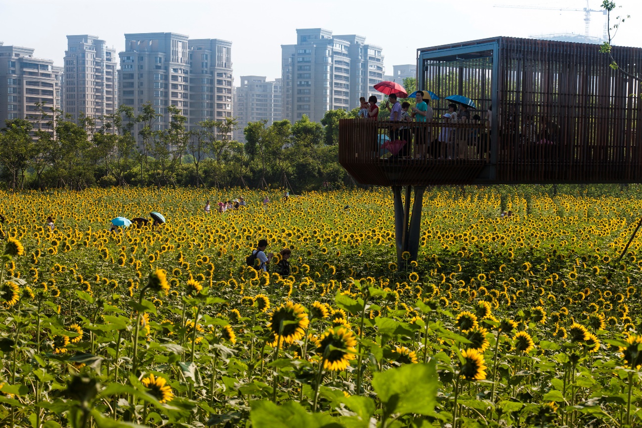
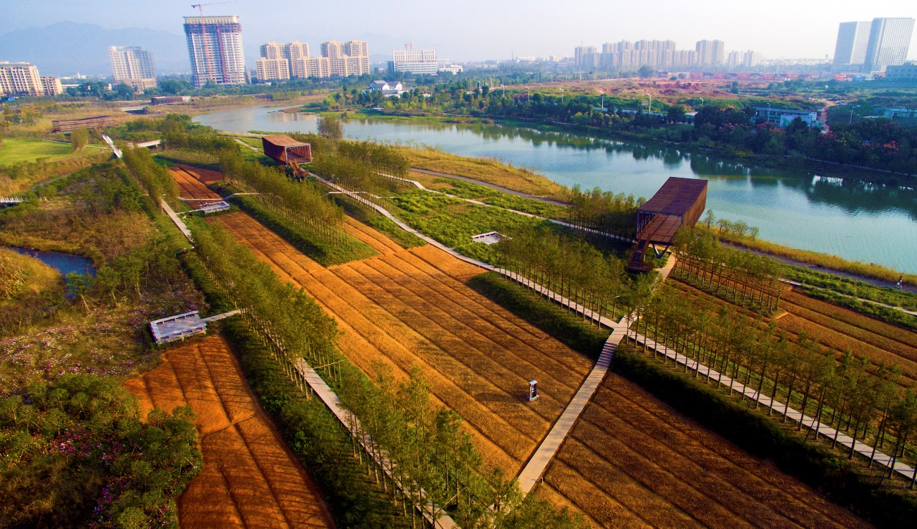
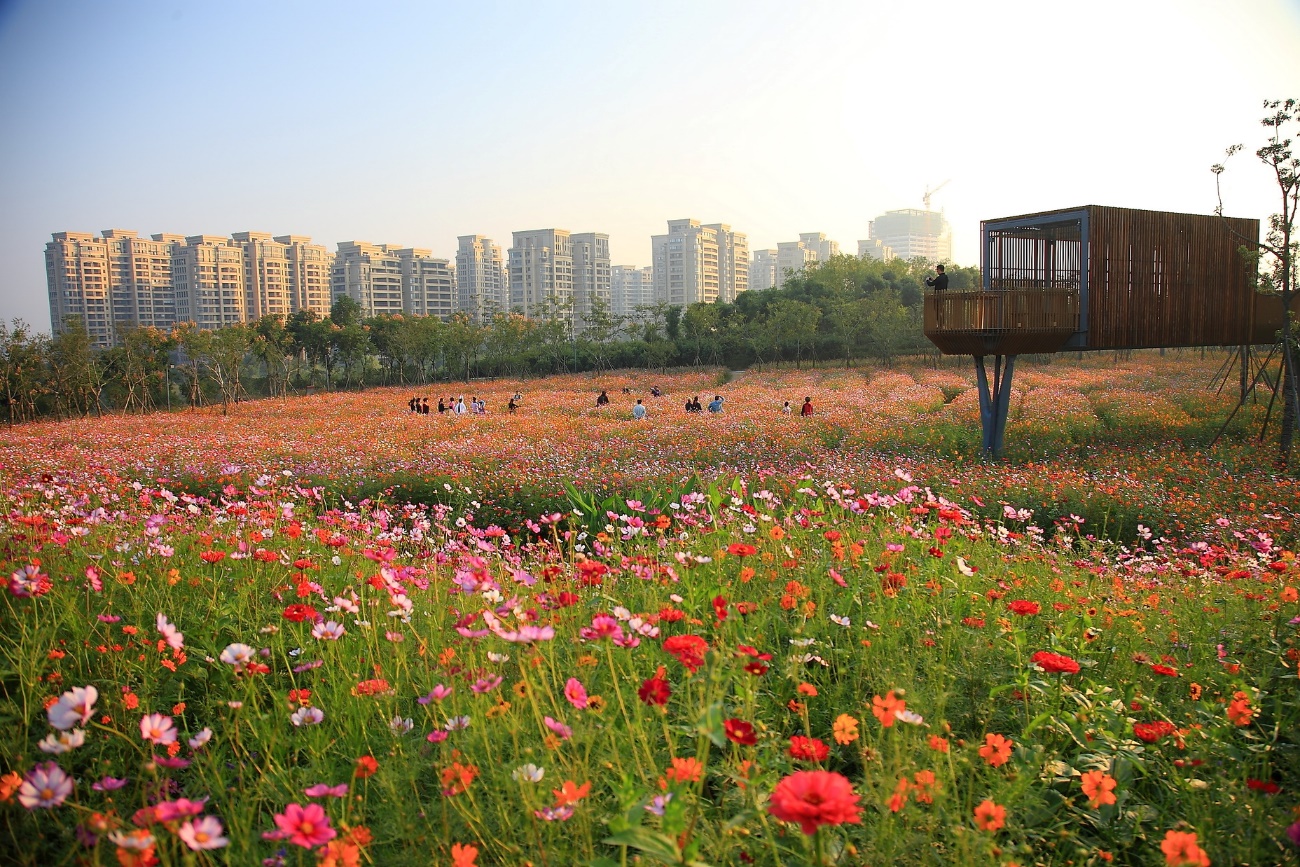
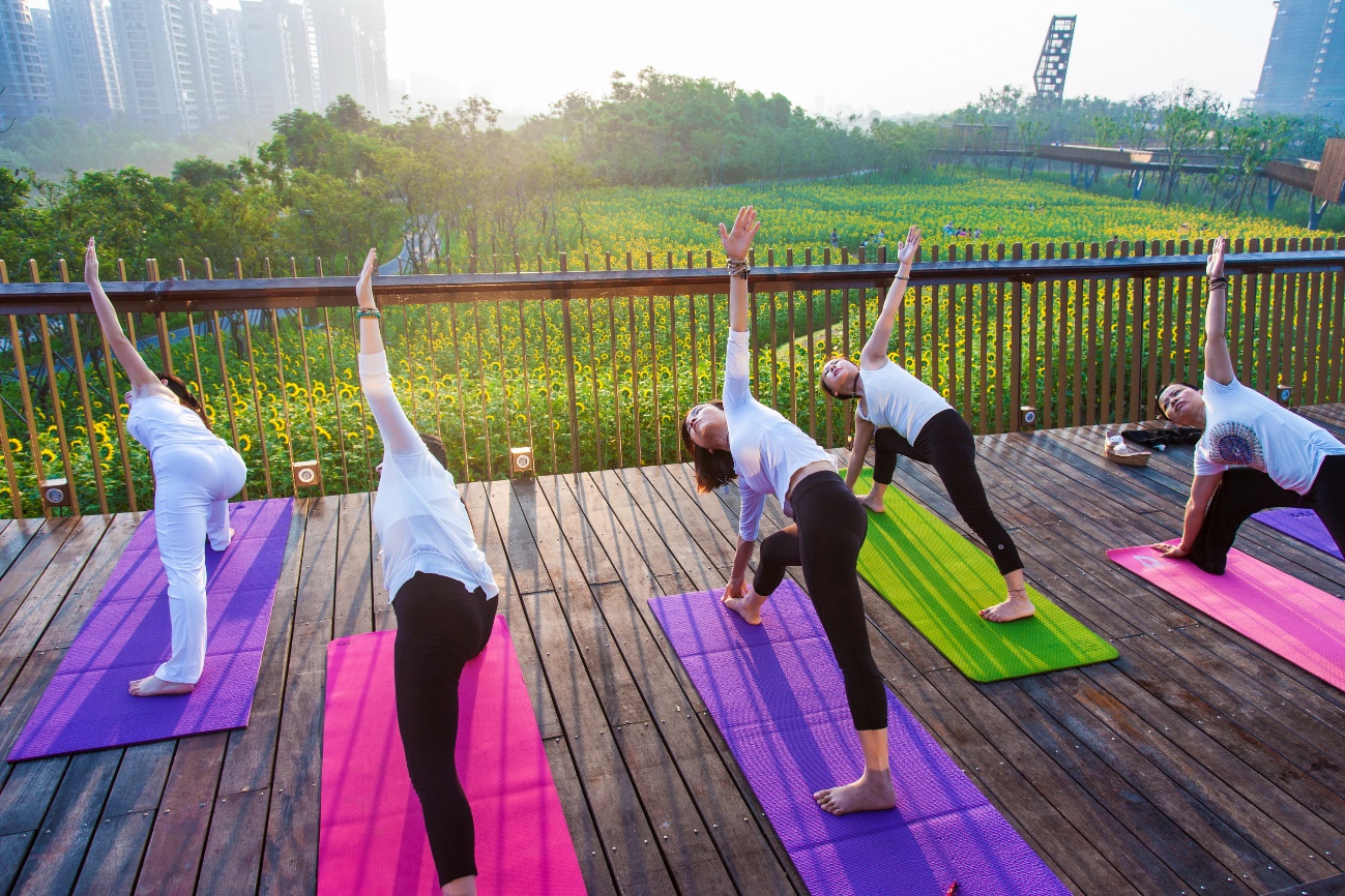
(2) Draping productive vegetation over the terrain and field: While the pre-existing habitats is preserved, productive crops are introduced to cover the abandoned fields. Four crops rotate year around following the season, Canola flower in the spring, sunflower in the summer and fall, and buckwheat in early winter. Flower meadows with mixture of species is also considered to rotate with other productive crops in some area. Patches of low maintenance perennial Christhantmum flowers that can be harvested as Chinese herb medicine is grown to enrich the landscape spectrum. Two patches of law are used when needed to be programed for camping, sport filed for kids, etc. This diverse pallets of vegetation create an overall productive and/or low maintenance canvas that encourage dynamic events and celebrations to be programmed around the seasons, besides providing day-to-day use of the park.
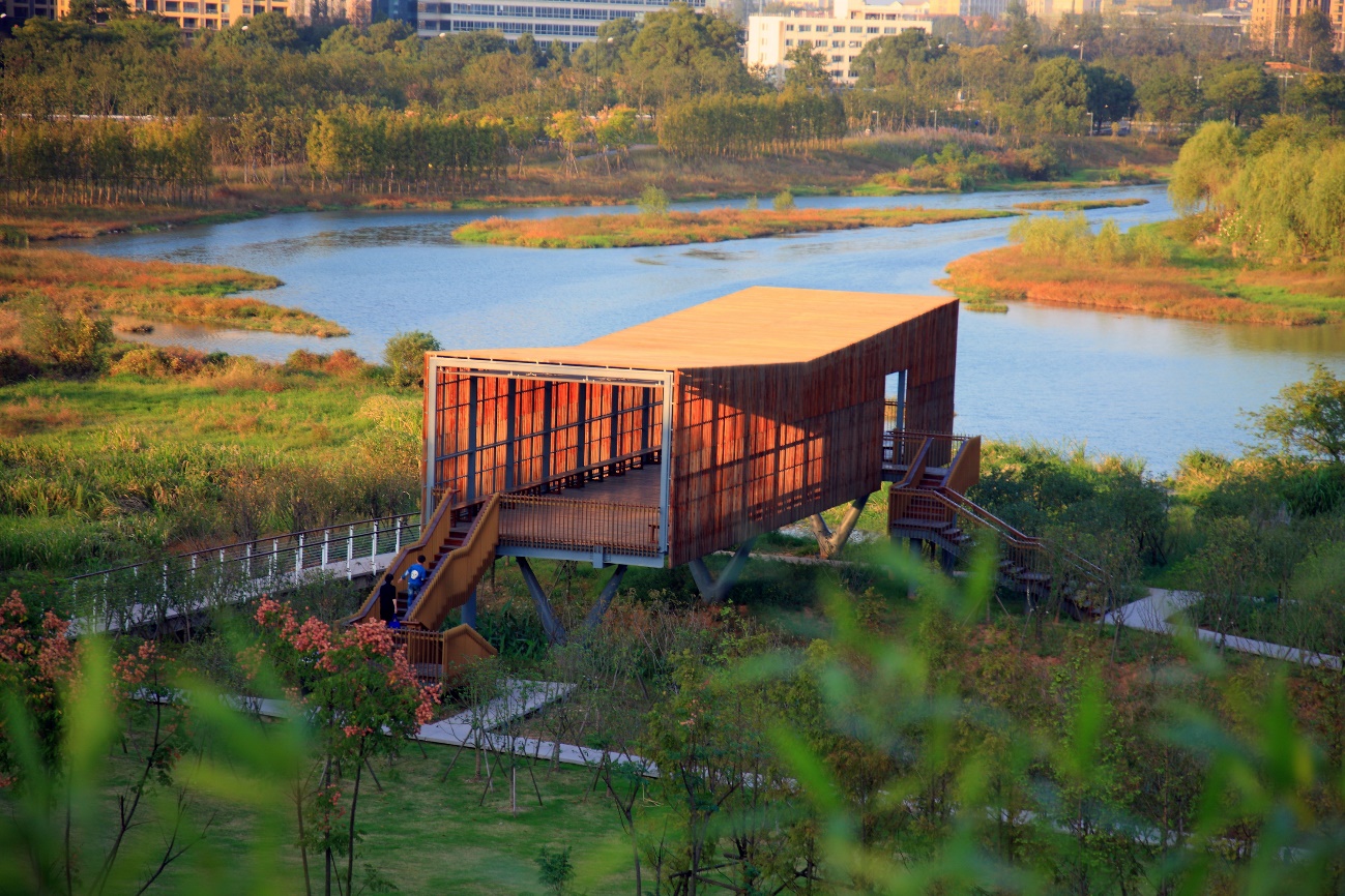
(3)Adapting the water process and to be water resilience: The pre-exiting drainage system on the site is kept unchanged, and additional bio-swales are added into the fields and slope to catch and filtrate the storm water runoff and be used for irrigation of the crops when needed; All ground payment is made of permeable materials, and no pipes nor irrigation system were built into the park; All concrete embankment which was installed before were removed and the river and wetland were let free with the fluctuation of river water, while a boardwalk is built floating above the river creating an unique access route allowing visitors to appreciate the red stone cliff which would otherwise be un-noticed; Pavilions were built to be flood friendly.
(4)En-framing the terrain and water by a network of paths and structures. Boardwalks, bridges, platforms, pavilions and a viewing tower is built into a experiencing network allowing visitors to have a rich experience of the mosaic landscape. This network of experiential facilities, while detached from the “canvas” that is made of the pre-existing mosaic of terrain, fields and water, over which draped over by the crops and/or low maintenance vegetation, will effectively transformed the productive and/or “messy” nature into a neatly order landscape and create a pleasant experience for the visitors.
(5) Telling the stories by an environmental interpretation: An environmental interpretation system is designed to tell the natural and cultural stories of the site in particular and the environmental awareness and responsibilities beyond the site.
4 Conclusion
The park was great success, not only is it a favorite place for local residents to fulfill their daily need of recreation, it has become a dynamic urban oasis with celebrations and all kinds of events that are spontaneously activated by the local communities through the social media along the seasons of flowers, keeping them being aware of the changes of seasons that have been almost buried in hustle urban life, making their memory refreshed being in the farm (80% of the urban residents, the same as the whole Chinese urban population were farmers back two or three decades ago). On a fine day, one can be easily moved by such scenes that happened at the same time in the park: kids of various ages jump and yelled in excitement in one of the pavillion floating above the lush vegetation, young boys and girls hug and falling in love with each other in one of the flower fields, a dozen newly married couples having their wedding photographs taken using the productive farm as their background, young couples caring their babies in stroller above the boardwalk, and elderly couple arm in arm walking and resting on the platform overlooking the city beyond the river that sprout like bamboo shoot from the farm land in just past couple years and that must has brought them so much memory of the past. Above the terrain, fileds and water, the draped over productive and beautiful vegetation, and the en-framing experiential network of boardwalks and structures, have not only kept the memory of the past but a prophecy and dream for the future, surrounded in an highly densified urban environment.

| Tipologia | Parcs urbans i metropolitans |
| Client | Quzhou City Government |
| Promoció | Pública |
| Coordinades | 28.971465, 118.836346 |
| Localització | Zhejiang, Quzhou, Xina |
| Àrea | 60 Ha |
| Any inici | 2013 |
| Any finalització | 2015 |
