


A 6th century archaeological site, Petra was named a UNESCO World Heritage site in 1968 and more recently named one of the “New Seven Wonders of the World” and showcased in the movies “Indiana Jones and the Last Crusade” and “Transformers.” In addition to its importance as an archaeological site and cultural icon, its tourism draw is the second largest component of the Jordanian economy.
Three prior studies had failed to comprehensively address the challenges plaguing the region - addressing only the existing urbanized areas of the region - comprising less than 10% of the total land area, and failing to address the vast archeological and ecological resources beyond those just within the existing archeological park. As a result of increasing unplanned tourism growth, Petra is in risk of losing its designation as a World Heritage Site. The region faces challenges with environmental degradation, population growth, child labor, limited water availability, unchecked development, lack of infrastructure and tourism accommodations, as well as complex challenges in managing the archeological park.
A multi-dimensional tension therefore exists between the need to protect and preserve the archaeological resource and to promote and sustain the tourism potential of the region for the economic benefit of the country. As a young tour operator expressed “this is not our treasure – we share it with the world and we need to hand it over undestroyed to our children…” Local residents and leaders understand that the integrity of these resources is critical to the long-term economic health of the region and the well-being of local residents. To address these challenges the Jordanian government established the Petra Development and Tourism Regional Authority (PDTRA) with authority over a 197,685 acre region including and surrounding the Petra Archaeological Park (PAP) which contains the most highly visited archaeological sites.
The team was retained by the PDTRA to prepare the Strategic Master Plan for the Petra Region, providing a guide to preserve the archaeological, ecological and cultural resources of worldwide importance while planning for the needs of future population - estimated to double in the next 20 years. The plan balances physical planning recommendations with strategies for economic and tourism development, exhibiting the full range of planning– from regional planning in the McHargian tradition to town-scale planning and placemaking. Such a comprehensive approach has been heretofore unknown in Jordan.
In a departure from prior plans, the Strategic Plan focuses on the entire 197,685 acre region, beginning with the creation of a comprehensive geographic information system database, the first such database of its kind on Jordan, which draws information from non-governmental organizations, national ministries and original research. The creation of a public database overlaying once disparate sources of information, many previously not available electronically, has resulted in a tool for collaborative land planning.
The land and infrastructure data was used to analyze land sensitivity and growth efficiency to identify areas for future development and areas for conservation. Over 400 participants including local leaders, women’s groups, youth groups and local subject experts provided input in prioritizing the land sensitivity factors such as steep slopes, wadis, views and agricultural soils. High priority was placed on protecting wadis (water drainages) from encroachment. Jordan is one of the most water-poor nations in the world, yet ironically overdevelopment in and along the existing drainages has led to flooding within and around the park, resulting in damage to the archeological sites. The Strategic Plan, therefore, calls for a watershed management concept for the region. Town boundaries have been re-organized by watersheds, with land coverage and zoning within each watershed balanced to prevent flooding and wadis zoned as conservation with substantial setbacks to discourage encroachment. The future land use plan sets aside 93.8% of the region as conservation zones and open space, providing a regional conservation system that links the Dana Reserve on the north with the newly designated Massouda and Rahmeh reserves on the south. Such a strategic solution provides for the “corridors and linkages” critical to the movement of wildlife within the region, but also calls for a network of trails and a “lodge to lodge” ecotourism strategy which will provide employment opportunities for the small villages of the region.
The conservation zone does allow for continuation of the pastoral use that is the economic tradition of the seven Bedouin tribes that occupy the landscape. An extensive public engagement process was employed to gain the input of both nomadic and urban residents of the region. In addition, the planning effort engaged national and international non-governmental organizations such as UNESCO, the Petra National Trust, and the Royal Society for the Conservation of Nature for valuable input. Gaining an understanding from the perspectives of these different groups informed a plan to discourage an over-dependence upon tourism and creation of concepts for promoting continued traditional practices. The Master Plan employs agricultural soils preservation regulations, ensuring that the current dryland farming practices may continue.
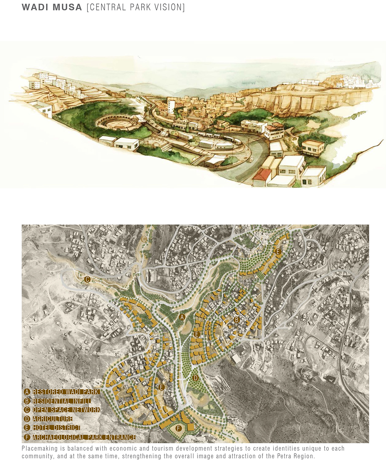
Zoning and placemaking plans were created for each of the six communities, taking into consideration public input regarding tourism development, density, character of development and transportation recommendations, including an integrated regional bus system which moves commercial bus traffic to an intercept parking and transportation facility at the outskirts of Wadi Musa, the major gateway to the Park. Tourists and locals are then transported via smaller, more environmentally friendly buses to the archaeological park and to the other communities and sites of the region. This was the first regional proposal for managing the transportation impacts of mass tourism.
The plan is recognized as an important step in the Petra area’s transformation from mere attraction to a global destination. The plan provides a long-term vision which guides the preservation of one of the Seven Wonders of the World serving as a model for similar circumstances which seek to balance tourism development with natural resource and cultural preservation.
| Tipologia | Planejament |
| Promotor | Petra Development and Tourism Regional Authority |
| Promoció | Privada |
| Localització | Petra Region, Jordània |
| Àrea | 800000000 m² |
| Any inici | 2011 |
| Any finalització | 2012 |